Natural Gas, Electric Power
October 09, 2026
Hurricane Isaias surges to Category 3 before forecast landfall Oct. 9-10: NOAA
Editor:
HIGHLIGHTS
SERC peakload forecast drops 16% week over week
Utilities mobilize thousands of restoration workers
The National Oceanic and Atmospheric Administration's National Hurricane Center said Oct. 9 that Hurricane Isaias had strengthened to a major hurricane before its expected landfall along the northern Gulf Coast, which is likely to disrupt energy infrastructure, fundamentals, and pricing.
Utilities serving the area threatened by Isaias, including those operated by Florida Power & Light, Duke Energy, and Southern Company, said Oct. 9 that they have prepared for the emergency.
In a webcast earlier Oct. 9, NHC Director Michael Brennan said maximum sustained winds had increased to about 120 miles per hour, placing it solidly in Category 3, a major hurricane on the Saffir-Simpson Hurricane Wind Scale. Category 3 storms have winds ranging from 111 to 129 mph.
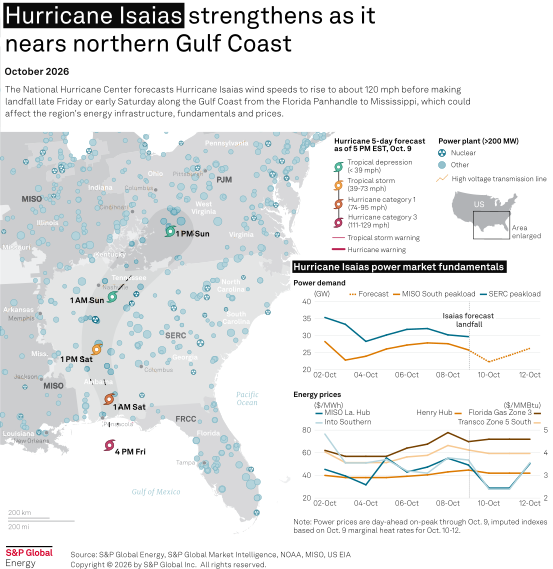
"This powerful hurricane is expected to make landfall this evening into the late night hours and then move quickly inland across portions of the Florida Panhandle and up into Alabama as we go through the overnight hours into Saturday and then move quickly up into the Tennessee Valley, Saturday night into Sunday," Brennan said.
The NHC's 10 am CT bulletin said the storm was about 195 miles south of Pensacola, Florida, traveling north/northeast about 16 miles per hour. The hurricane warning was in effect from Ocean Springs, Mississippi, to the line between Bay and Gulf counties in Florida.
The tropical storm warning area extended west from the Mississippi hurricane warning area to the Jefferson/Plaquemines parish line in Louisiana and east from the Bay/Gulf county line in Florida to the Aucilla River in Florida.
"Those strong damaging winds are going to penetrate quite far inland," Brennan said. "We also have tropical storm warnings now issued all the way up through portions of central and even northern Alabama and western Georgia.
High wind warnings were in effect for the Atlanta metro area and Tennessee, Brennan said, "where we could see scattered power outages and tree damage ... Saturday."
Tornado risks surge as the outer bands cross the Florida Panhandle into southern Georgia, Brennan said.
Market impacts likely
For 11 cyclones making landfall along the Gulf and Atlantic coasts from 2022 through 2025, power demand dropped about 20% from the same day of the week prior, usually due to power outages, an S&P Global Energy analysis shows. Day-ahead on-peak power prices dropped an average of almost 30% from the week prior. Spot natural gas prices fell an average of 12.5% from the prior week.
The North American Electric Reliability Corp.'s SERC Region — formerly known as the Southeast Electric Reliability Council — was forecast to have a peakload of 29.7 gigawatts Oct. 9, according to US Energy Information Administration data. This is down nearly 5.7 GW, or about 16%, from a peak of 35.4 GW Oct. 2.
However, Platts assessed natural gas at the Transco Zone 5 South location, important for mainland Southeast wholesale bilateral prices, at $4.12/million British thermal unit for Oct. 9 delivery, up 8 cents from the Oct. 2 index of $4.04/MMBtu.
Into Southern day-ahead on-peak bilateral power did not trade on the Intercontinental Exchange for Oct. 9 delivery, but applying on-peak marginal heat rates from Oct. 8 to that Oct. 9 gas index would result in an Into Southern day-ahead on-peak power index of $53.55/megawatt-hour for Oct. 9 delivery, down nearly $23, or 30%, from $76.50/MWh Oct. 2.
Water issues expected
Storm surge warnings were in effect from the mouth of the Mississippi River east to the Suwannee River in Florida. A storm surge watch was in effect from the Suwannee River to Yankeetown, Florida.
Storm surge forecasts were:
- 6-9 feet above normal from the Alabama-Florida state line to Grayton Beach, Florida.
- 4-7 ft from Grayton Beach to Indian Pass, Florida.
- 4-6 ft from Indian Pass to Steinhatchee River, Florida, and from Dauphin Island, Alabama, to the Alabama-Florida state line
- 3-5 ft from Steinhatchee River to Suwannee River, from the mouth of the Mississippi River to Dauphin Island, and in the Lower Mobile Bay.
"Through the weekend, Isaias is expected to produce rainfall amounts of 4-8 inches across southern Alabama, the Florida Panhandle and Big Bend, and southwest Georgia," the NHS update said. "Localized totals up to 15 inches are possible, particularly within banding across the Florida Panhandle and Big Bend."
Utilities prepare
Florida Power & Light, which serves most of the Florida Panhandle, said has staged more than 12,000 workers at 16 sites across northwest Florida, FPL President and CEO Scott Bores said during a news conference about 10 am CT Feb. 9.
Outer storm bands had passed through the region before Bores' news conference, he said, adding that "we will have our crews out there in between the feeder bands when it is safe to do so, restoring power for our customers." Bores said the storm is expected to make landfall as a Category 2 storm, with wind speeds of 96-110 mph.
"This is a very strong and dangerous storm," Bores said. "We are going to have outages. No system is stormproof. We have invested to harden our system, which will help us be able to restore more efficiently after a storm passes, but we are going to have outages."
The storm surge and potential heavy rains "may make some areas inaccessible after the storm passes," Bores said.
"We are committed to restoring every customer, and we'll be with all of you until the storm passes and every customer is restored," Bores said.
Duke Energy, which also serves much of northwest Florida, said Oct. 9 it had mobilized "thousands" of workers from across the state to support power restoration in affected areas.
"As soon as Hurricane Isaias passes and conditions are safe, we'll work quickly and tirelessly to get the lights back on for all affected customers," said Todd Fountain, Duke Energy Florida storm director.
Alabama Power said in an Oct. 9 news release that it had adjusted work schedules and positioned crews and equipment to go where needed. It has 5,700 additional workers from 25 states coming to help restore power as quickly as possible.
"Our teams train and plan for events like this throughout the year, and that preparation gives us the flexibility to make informed decisions and adapt as the forecast and potential impacts become clearer," said Scott Moore, Alabama Power senior vice president for power delivery.
